OUR RESERVES
All reserves have free access for NOA members from dawn to dusk.
For non-members a permit fee is charged for access to Holme Bird Observatory, current price £3 per person. This includes parking in the NOA Car Park at Holme.
Please note: Under 16s have free entry. A members’ key is required for access to members hides at Holme Bird Observatory, Redwell Marsh, Walsey Hills and Hempton Marsh.
Our principal reserve and the only accredited Bird Observatory in Norfolk. Located at a migration hot spot, Holme Bird Observatory is a link in the chain of Bird Observatories around the coasts of the UK collating information about bird movements and populations, mostly from ringing and census counts. The site is manned throughout the year. As well as birds, daily records of insects, mammals, reptiles and amphibians are kept, with moths trapped and released daily from March 1st through to October 31st. Members and visitors are welcome to come and see bird ringing and moth trapping taking place.
Read MoreHolme Bird Observatory reserve is designated as a Site of Special Scientific Interest (SSSI). Owing to its key location on the Norfolk coast, birds travelling from east to west on migration are often grounded by the change in the line of the coast, which drops away to the southwest and into the Wash. This local geography causes the pines and dune scrub at Holme to stick out into the North Sea, focusing birds on this apex. Holme Bird Observatory enjoys the close proximity of several different habitats; the sea, beach, dunes, pine woods, scrub, salt and fresh marsh all contribute to an incredibly varied wilderness. The site itself consists of 10 acres in total, and the habitats are full of important sources of food for migrating birds, together with drinking pools and sheltered scrub where birds can feed, bathe, and rest.
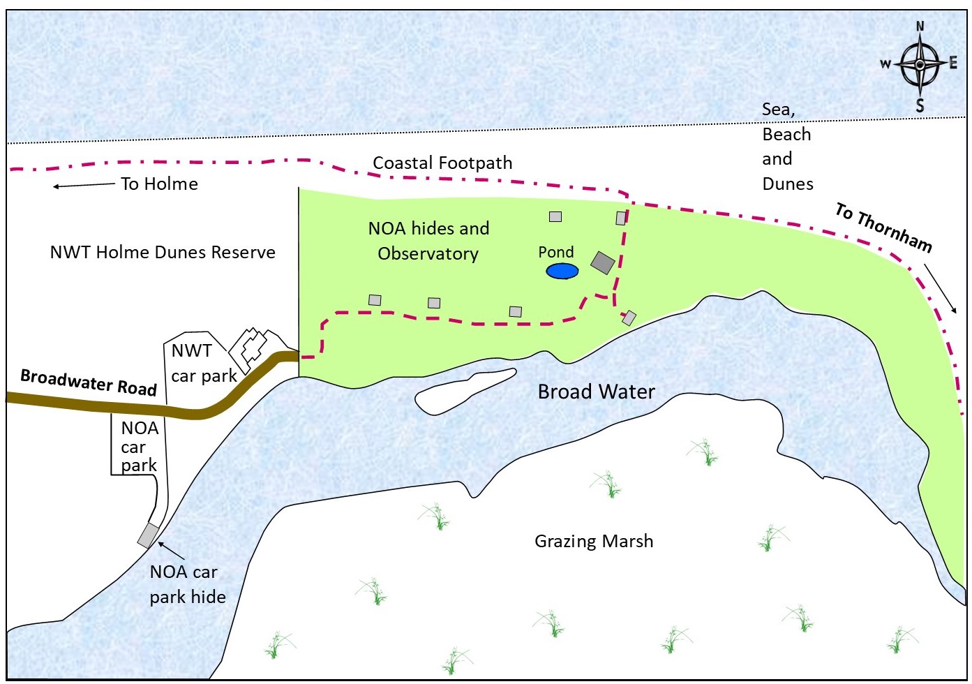
Ringing takes place when weather conditions permit, and a ringing laboratory where visitors can see ringing on suitable days is found just behind the Observatory centre. A purpose built seawatching hide stands high in the pine trees looking north west over the dunes out to sea. There are six other hides; a shelter near the coastal footpath at the northern boundary, one looking over the Broadwater a short distance along the east bank, three viewing hides along the main bank west of the visitors’ centre, and finally a members’ hide in the NOA Car Park, which gives a good view of birds at the west end of the Broadwater.
Over 300 species have been recorded at this renowned site, and more exciting visitors have included Caspian Tern, Black Kite, Red-rumped Swallow, Alpine Accentor, Bluethroat and Red-flanked Bluetail. In the autumn in particular rare migrants such as Barred, Yellow-browed, Pallas’ and Dusky Warblers can be found here. In its sixty years to date Holme Bird Observatory has ringed over 80,000 birds and recorded some amazing journeys to and from far flung sites such as Israel, Nigeria and Siberia.
The Observatory also studies butterflies, moths and dragonflies, mammals, reptiles and amphibians and is home to a number of rare plants.
Access Information
All visitors who do not have a current NOA membership can access the Observatory for a day permit per person, price currently £3.00. All under-16s are welcome free of charge.
Access for members is between dawn and dusk, and for permit holders between 9am and 5pm.
The site is accessible both by car from Holme village along Broadwater Road, and on foot from the Norfolk Coast Path between Holme and Thornham villages.
Disabled parking spaces are available in the NOA staff car park, which lies beyond the NWT visitors’ centre to the east. Access to the Observatory centre and viewing platform is provided by access ramps at the west and east end of the main bank, and a ramp up to the viewing platform beside the Observatory building.
Wheelchair access is also provided in the Car Park and Dell Hides, which are adapted for wheelchair use. The Car Park Hide can be accessed from the main NOA Car Park but a members’ key is required.
Cycling: is permitted on Broadwater Road only; please do not cycle on the reserve or the coastal footpath, as this is prohibited.
Dogs are welcome on leads.
Redwell Marsh is a cattle-grazed coastal wetland with scrapes, ditches and natural freshwater springs. It principally attracts wildfowl and waders but is home to a wide range of bird species and a good place to look for migrants.
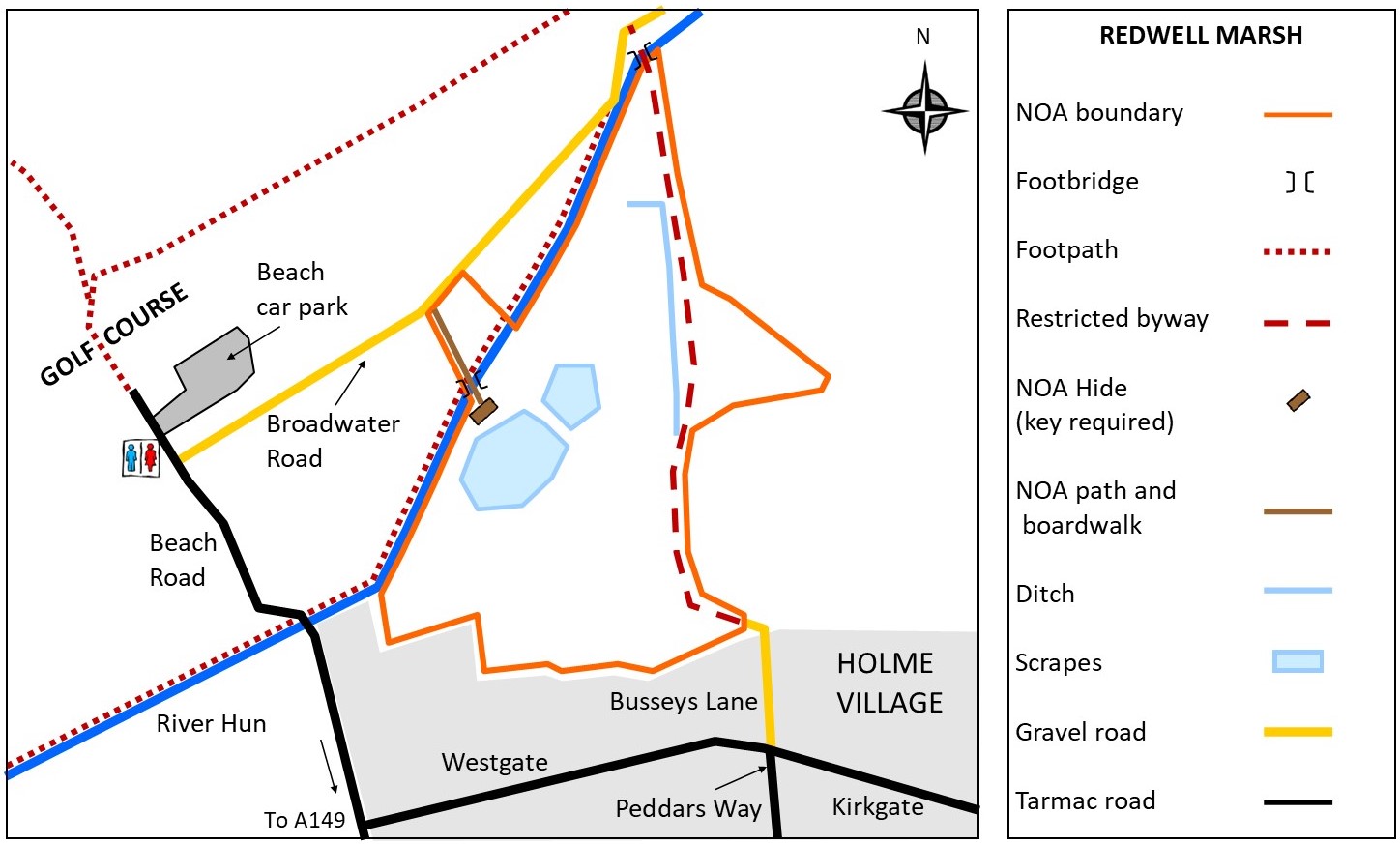
Read MoreCovering 14 hectares and managed under Higher Level Stewardship, the reserve is designated as a Site of Special Scientific Interest (SSSI), a Ramsar Site and lies within the North Norfolk Coast Special Protection Area (SPA), and the Norfolk Coast Area of Outstanding Natural Beauty (AONB). Situated just south of the River Hun, a footpath runs along the eastern boundary, and a member’s viewing hide is accessible from Broadwater Road.
Birds and other Wildlife:
Redwell Marsh tends to flood in winter and dry out in summer. When there are muddy margins on the scrapes these can attract Common, Green and Wood Sandpipers, Black-tailed Godwits, Common and Spotted Redshank, Greenshank and Snipe among others. In some years scarcer species such as Red-necked Phalarope, Temminck’s Stint and Pectoral Sandpiper have been recorded. Visiting wildfowl have included American Wigeon and Garganey. Barn Owl and Cetti’s Warbler can be seen throughout the year, Kingfisher and Water Vole can be present on the river.
Reserve History
NOA purchased the reserve in 1985 with a significant grant from the World Wildlife Fund, together with smaller donations. A sluice gate was installed in 1996, and further improvements in 1998 and 2004 increased the water levels and enhanced the site for wildlife. This was followed by the construction of a bird hide in March 2001. A bridge crosses the River Hun to the hide, and the boardwalk was renewed in 2014 thanks to a grant from the Goldcrest Charitable Trust, bringing it up to modern wheelchair standards.
Access Information
A members key is required to use Redwell Marsh Members’ Hide. This is accessed via a boardwalk suitable for wheelchairs, and the hide is adapted for wheelchair use. The hide gives excellent views over the whole reserve including the scrapes. Members may use the hide from dawn to dusk and more information on how to join can be found here.
The restricted byway across Redwell Marsh runs adjacent to the eastern boundary of the reserve, emerging at Broadwater Road to the north and Busseys Lane in Holme village to the south. The byway is often muddy, and walkers may sometimes have to cross flooded areas. Cattle are on the marsh between April and November and walkers may encounter grazing animals when crossing the reserve, so please take care.
Conservation Grazing Area:
Please help protect wildlife on Redwell Marsh when crossing the reserve on foot, by keeping dogs on leads, keeping to the path and closing gates. Thankyou.
Directions and facilities
The reserve is situated on north side of Holme-next-the-Sea village off (Broadwater Road). Visitors can use the public car park at the north end of Beach Road (near the Golf Course), where there are public toilets. In dry conditions parking is permitted in the paddock off Broadwater Road. Parking is also available for NOA members and visitors in the NOA car park at the eastern end of Broadwater Road.
Redwell Marsh Grid Reference: TF70143
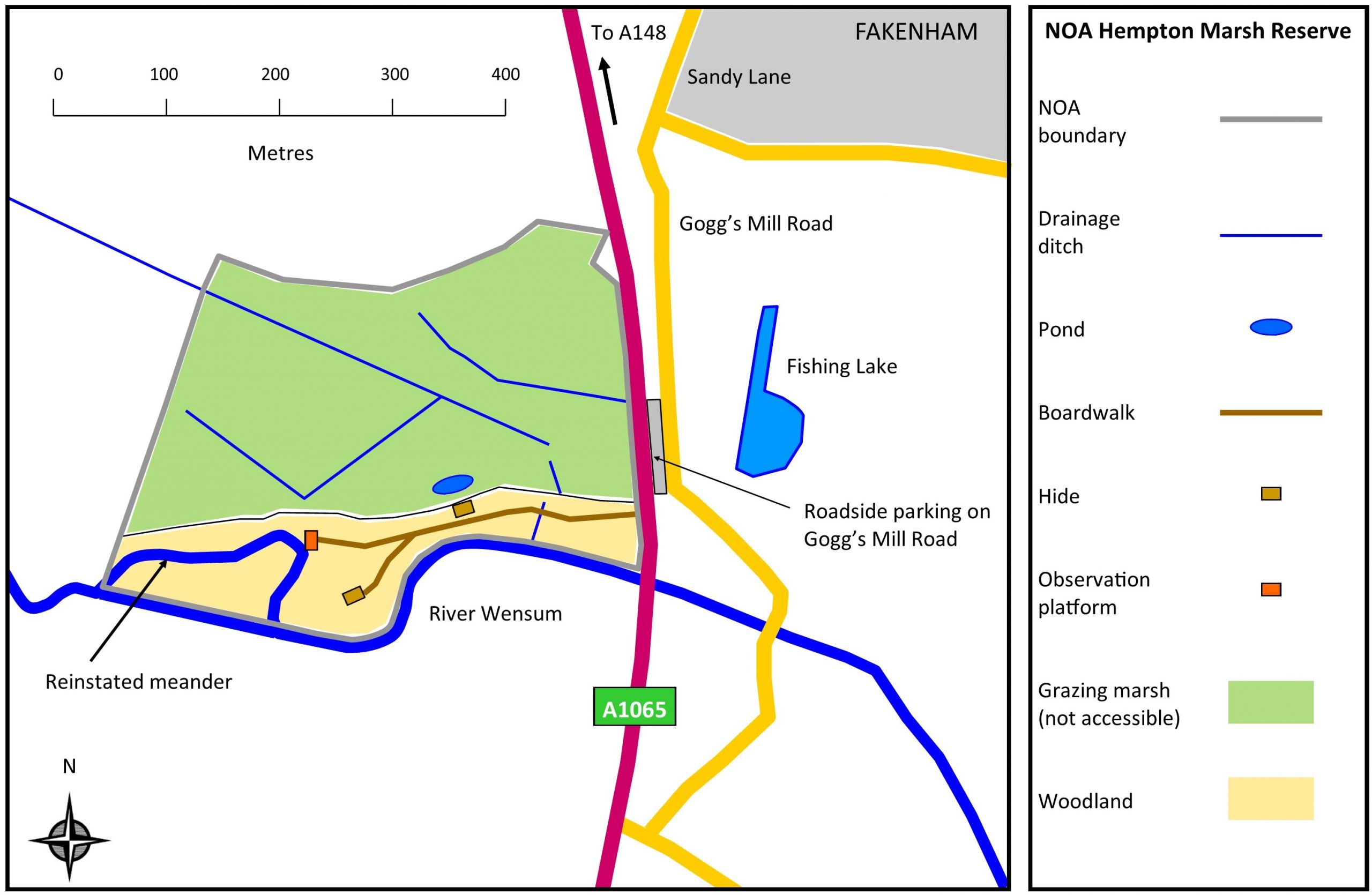
Hempton Marsh Nature Reserve consists of 29 acres (12 ha) of ancient wet meadow and mature woodland, situated on the south-western outskirts of Fakenham, and bordered on the south side by the River Wensum. It is home to a variety of rare wetland plants including Southern Marsh Orchid and Yellow Rattle, and is attractive to many birds and insects. The site is wardened regularly by a team of volunteers.
Read MoreHempton Marsh is part of a natural flood plain and the marsh is cattle grazed between April and November. A boardwalk running through mature alder carr and scrub looks out onto the grazing marsh, with a members’ hide (called the Marshland Hide) looking north. The boardwalk then winds on through to a woodland clearing with bird feeders and another hide (the Woodland Hide) where visitors can observe birds at the feeders. A second branch of the boardwalk leads to an old river meander, reinstated in 2002, which lies in the south western corner of the marsh. The NOA runs a moth event and ringing demonstration at Hempton Marsh each year. Visitors are welcome to see ringing take place when the circumstances permit.
Birds and other Wildlife
Marsh Harriers, Buzzards and Red Kites regularly soar over the reserve in spring, and Barn Owls can be seen hunting over the wet meadow. Many warblers call the reserve home for spring and summer including Blackcap, Chiffchaff, Willow Warbler, Reed Warbler and Sedge Warbler. Between April and June Cuckoos are frequently heard. Kingfishers often zip up and down the river and Water Rail can be heard. Great White Egrets, Little Egrets and Herons can be found in the main channel.
In winter Redwings and Fieldfares enjoy the many berries on offer. The large alder trees attract finches such as Redpoll, Siskin, Goldfinch and Brambling, and these birds together with Marsh Tit and Great Spotted Woodpecker, sometimes come down to the feeders at the Woodland Hide. In winter the wet meadow floods becoming a feeding and roosting site for waders like Snipe, Woodcock and occasionally Jack Snipe. This flooded area is also good for gulls and ducks.
With the use of trail cameras around the reserve we discovered Otters are frequent visitors using the many waterways. Other mammals include Roe Deer, Water Vole, Water Shrew and Stoat. The marsh is an important site for flowers with good numbers of Southern Marsh Orchids and Yellow Rattle, and a wide range of other species which favour wet grassland. The site also supports a wide range of invertebrates including butterflies, moths, dragonflies and damselflies. While there is no public access onto the meadow, these species can be seen and enjoyed from the hides and boardwalk.
Reserve History:
The reserve was purchased in 1999 through a Heritage Lottery Grant. Since then the NOA has focussed its efforts on the development of the habitat at the site, including restoration of an ancient meander in the river. In addition, there has been systematic monitoring of the wildlife here. Further funding from the Heritage Lottery Fund in 2006 permitted the NOA’s ‘Access to wildlife at Hempton Marsh’ project, supplemented by matched funding from Jordans’ Cereals. This project allowed the construction of a boardwalk and hides to give effective public access to the site without damage or disturbance to the habitat. The reserve was officially opened in April 2008, and public events are run at the reserve each year including moth days and ringing demonstrations. The NOA’s work to protect and develop the habitat of the site attracts Higher Level Stewardship funding.
Access Information
Hempton Marsh has two members’ hides adapted for wheelchair use and accessed by a boardwalk suitable for wheelchairs.
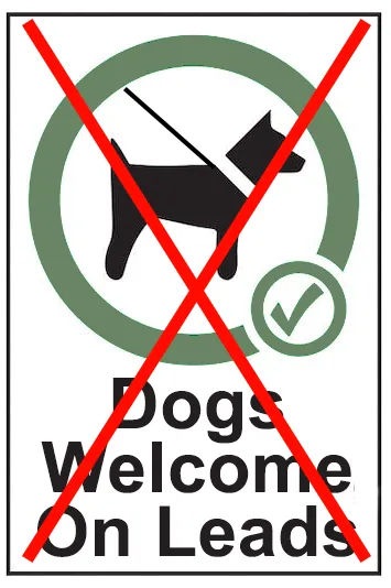
We regret that this reserve is not suitable for dogs and cycling is prohibited.
Caution: To access the reserve visitors must cross the A1065 which is potentially hazardous, and we do not recommend wheelchair users attempt to access the site without help. We regret that due to the planning regulations concerning the Fakenham bypass, we are not able to offer any parking at the reserve entrance on safety grounds.
Directions and Facilities
The entrance to the reserve is located on the A1065 just west of Fakenham where the road crosses the River Wensum. Parking is available, along Goggs Mill Road, a minor road running parallel to the A1065, (see map). To reach it, follow the A1065 south from the roundabout with the A148 just west of Fakenham. About three quarters of a mile down the A1065, just after the bridge over the river Wensum, take the first turning left towards Fakenham Garden Centre, and then immediately left again, before the Garden Centre itself, following a single track road. Follow this road (which has several bends and a number of pull-off places) until you reach a pull-in on the left which faces back towards the bypass. Please park considerately. Visitors will need to cross the bypass on foot, which will bring them directly to the reserve entrance.
Grid reference: TF 913296.
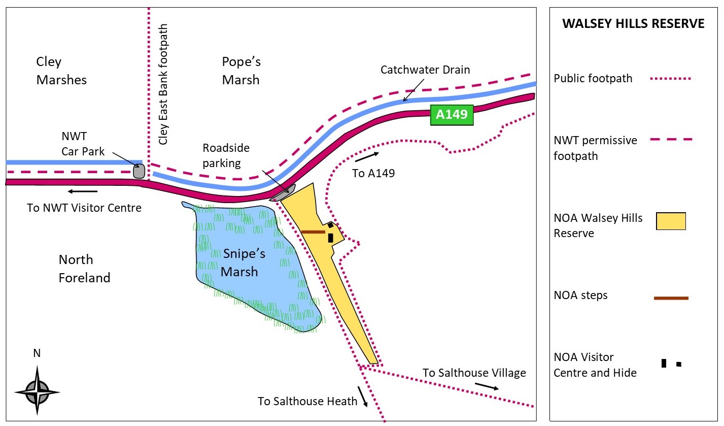
Walsey Hills Migration Watchpoint is a hillside reserve of 3 acres (1.2 ha) beside the A149 coast road, situated between Cley and Salthouse villages. Being located close to Cley’s East Bank, the site offers superb views across the coastal marshes and across Snipes Marsh to the woodland of the North Foreland.
Read More
The public footpath to the east of the reserve affords excellent views over the new Pope’s Marsh section of the Cley Marshes NWT reserve. The thorn and gorse scrub provides shelter for migrating birds, often attracting scarcer species. Besides birds, the hills are also frequented by Slow Worms, Common Lizards and a variety of insects. The reserve is currently staffed at weekends from March to November by our assistant warden Emma Buck (see across), and volunteer wardens may be present on other days. Birds and other Wildlife: An important migration watch-point, the site has attracted some unusual species in recent years including Red-backed Shrike, Alpine Swift, Honey Buzzard, Richard’s Pipit, Little Bunting, and Dusky, Yellow-browed and Pallas’s Warblers. More regularly Cetti’s Warbler, Pied Flycatcher, Common Redstart, and Firecrest can be found. The adjacent marshes provide habitat for a wide range of wildfowl and waders. In fields to the south, farmland birds such as Yellowhammer may be present. Reserve History: Walsey Hills was once used by the former Cley Bird Observatory and was an important ornithological site even prior to 1950. The site was used for bird ringing and monitoring, and a Heligoland trap was built here in 1951. Despite being damaged in the North Sea surge of 1953, the trap was repaired and continued to be used for bird ringing and monitoring until the end of 1963. The site is also of wider historical significance because of its Royal Observer Corps underground monitoring post (the ROC Cley-next-the-Sea “bunker”). Buildings like this were designed as fallout shelters in the 1950s, for use as monitoring posts in the event of a nuclear war. They were buried underground and equipped with scientific and communications equipment, as well as bunk beds, chairs, basic lighting and a chemical toilet, to allow personnel to monitor external conditions from the inside over a prolonged period. Built in 1958, the monitoring post was closed in 1968. The site’s ornithological role then resumed and the Norfolk Ornithologists’ Association (NOA) undertook bird ringing at the site from 1970. The NOA then purchased the site from Norfolk County Council in 1973. Now partially uncovered, the former bunker serves as a visitor centre, where bird movements and numbers are observed and recorded, together with information about insects and other wildlife. There is also a hide which was formerly an ROC aircraft monitoring station, built in 1953 on this high vantage point. The hide was rebuilt in 2004, using funds from the NOA and its supporters, and can be used by members visiting the reserve. The steps leading up the hill from the public footpath to the bunker were extensively repaired in 2001, and then replaced to a high standard in 2009 thanks to a grant from Awards for All, one of the National Lottery’s award schemes. The reserve is open from dawn to dusk, during which time you are most welcome to visit, to enjoy the wildlife and the views over the surrounding countryside. When a warden is present, you will also be able to access the observation hide and visitor centre. NOA members who have a hide key will be able to access the hide at other times. Non-members visiting when a warden is present are invited to contribute to the upkeep of the reserve. In the event of a rarity being present, the NOA reserves the right to charge a permit fee for non-members accessing Walsey Hills. Anyone wishing to visit the former ROC structures is urged to contact the NOA well in advance, to arrange a visit when a warden can provide access, although both buildings can be viewed externally at other times when the reserve is open. Access Information Walsey Hills is accessed via a long set of steps but these provide handrails and resting points for those with reduced mobility who are still able to make their way up on foot. Please be aware that this is a hillside site, and we regret that wheelchair access is not feasible. The visitor centre is reached by a flight of 46 wooden steps; the gradient of the steps is relatively gentle, and there are two landings, each with a small bench on which to rest. There is a further flight of 13 steps to reach the hide. There are no rights of way on this reserve, but three sit near to its boundaries. Visitors are asked not to cut through between the surrounding public footpaths, this damages fences and disturbs wildlife. Your co-operation is appreciated. Please contact NOA for more information on 01485 525406. Dogs are welcome on leads (symbol) Directions and facilities Walsey Hills is situated on the A149 midway between Cley-next-the-Sea and Salthouse. The reserve is signposted, and parking is available on the roadside adjacent to the reserve (sometimes also in the small NWT car park at the south end of the East Bank). The nearest toilet facilities are half a mile west along the main road at Cley Marshes NWT Visitor Centre on the A149, which can be reached via the NWT’s permissive footpath from the East Bank. Grid reference: TG062441. Grid ref of carpark TG062442.
